The right infrastructure in the right place, at the right time, for the right reasons

OCP recently worked with the Presidency of Taiwan to hold an international hackathon, inviting participants from around the world to propose solutions for building better and sustainable infrastructure, using open data. The event was a huge success, and we were very impressed with the smart and innovative work produced by all participants. We’re proud to feature the top teams’ projects in this blog series.
In July 2019, MasTeam was successfully shortlisted for the finals of the Taiwan Presidential Hackathon. Our team members from the Malaysian Administrative Modernisation and Planning Unit (MAMPU) were extremely excited to have been chosen from almost 30 other talented groups from across the globe for the final round in Taipei.
Our project sought to improve the planning and delivery of public health and education infrastructure by developing a data-driven tool for identifying optimal locations for schools and hospitals. We were inspired by the huge investment needed for education and health facilities in Malaysia. In 2018, our government allocated more than RM650 million (US$155 million) to build preschools, primary schools, matriculation centres and other educational facilities. Similarly, the government spent around RM1.4 billion (US$334 million) on building hospitals and other healthcare centres that same year.
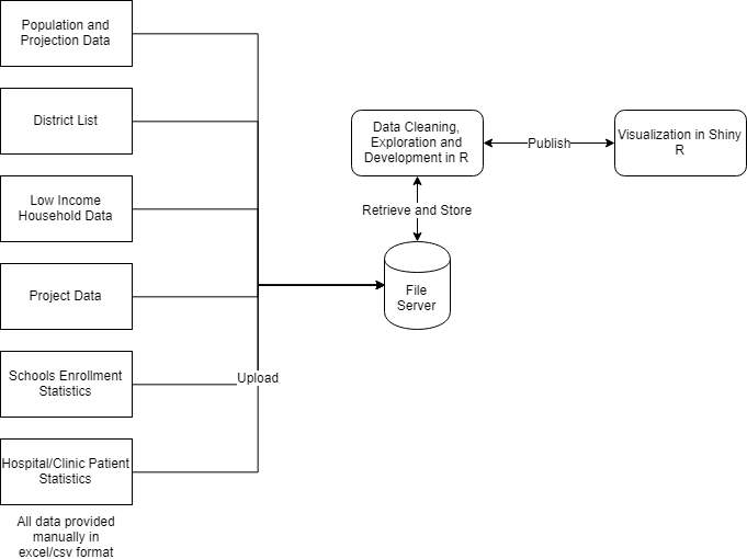
Given this significant investment and its potential for transforming or saving lives, we wanted to develop a tool to help the Ministry of Education and Ministry of Health to more accurately assess and determine the best locations for schools and healthcare facilities by joining up procurement data with capacity and utilisation data, as well as user needs data. Specifically, the tool would analyse relevant information for each group of facilities, such as past/current procurement data, population growth, facility capacity, global standards (for example student-to-teacher ratio or hospital beds-to-population ratio), distance to facilities, types of services offered, and other parameters (see system architecture below). These details would allow procuring entities to make better and more informed decisions to build the right infrastructure in the right places, so that citizens truly benefit from these investments.
High-level architecture:
Given the infrastructure spending gap and limited resources available, it is paramount that such vital infrastructure is built in locations where there is the greatest need – not only for citizens to gain access to better services, especially those in the low income category, but for our government to get better value for money too.
Building the prototype
So how did we go about this? To demonstrate our prototype, we focused on sample data from all the districts in the country.
We plotted the distribution of Malaysia’s entire population (including low income and school-attending age categories), schools and health facilities (both current and under construction) to gain an understanding of the current situation and get some figures on facilities/population ratios. We also used population projection data to estimate the capacity gaps in 2025.
Then, we converted the school and hospital project data obtained from the government’s project monitoring system (SPP II) into OC4IDS format, as this standardized format allows interoperability. So far, we have already converted data from almost 1,500 schools and hospitals into OC4IDS. This open contracting approach helped us join up different datasets to provide metrics on health and education facilities construction, which will guide policy makers in planning and delivering the needed infrastructure. We then added this project data into the existing visualisation layers created, based on population, enrolment etc.
From our initial data analysis using the prototype, there are districts that are overpopulated and schools oversubscribed, meaning the local children are forced to travel significant distances to the adjacent districts to gain entry into schools. As for hospitals, the majority of them fail to meet the recommended standards set by World Health Organisation, for example the minimum number of beds requirements. As the prototype uses minimal parameters as a starting point, additional parameters that are unique to the respective areas (education and healthcare) may yield different results.
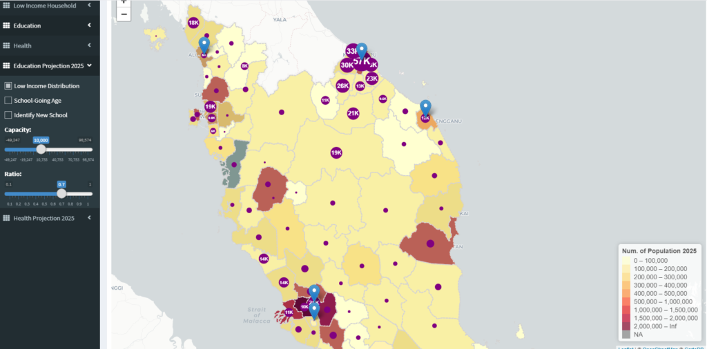
Recommended locations for schools based on capacity gap (<10,000) [that is, the difference between a district’s expected school-going population in year 2025 and the number of students that schools in the area can accommodate] and capacity:population ratio (0.7) [that is, the number of enrolment places for every person in the district]
Having delivered a proof of concept in Taipei, we are now working to improve the prototype to include updated datasets, better visualisation, and scalable caching mechanism for faster data retrieval and display. Currently the proof of concept uses five years of procurement data, which encompasses over 140 districts in more than 16 states/territories, and the construction of about 80 schools, 10 hospitals and 100 clinics over that period. As more datasets and integrated, scalability and usability will be critical.
Secondly, based on the initial exploration above, we will develop a comprehensive list of optimal locations for schools and health facilities for the 12th Malaysia Plan (2021-2025), according to the most urgent or greatest needs. Our recommendations will prioritise infrastructure projects that offer the best return on investment in terms of social impact and value for money. Essentially this tool will help align investment with needs so, for example, the areas with the greatest needs receive the greatest investments. This will ensure a fairer distribution of funds across regions whilst reducing the strain on public services by improving the facilities to population ratios.
Finally, we also aim to incorporate related procurement data such as cost and duration of construction projects to identify patterns, variations, anomalies and other insights that may further enhance the utility of this tool.
All of this will be provided as an interactive dashboard that displays the visualisation map. Users can make parameter selections and the appropriate results will be updated on the map. This provides an easy interface for users to self explore various options for building the infrastructure and also to discover insights about current and future infrastructure projects.
Achieving impact
For decision-makers in the education and health ministries who are involved in planning for the 12th Malaysia Plan (2021-2025), our tool offers an evidenced-based, joined-up reference that will add value to their internal processes. It will also help in better budgeting and project management planning by referring to current construction cost and duration. Ultimately, the benefit extends to the public as schools and health facilities are built in areas that are in need, thus maximising the number of people served.
In the long term, we will continue to develop this prototype and enhance its scope so that it is continually improved. We will aim to integrate additional parameters, for example transportation data (the distances/time taken to travel to schools/hospitals) as we know that this is one of the major barriers and cost centres which prevent poorer households from accessing these health and education services. We hope that the prototype can evolve to cover more facilities such as tertiary education, welfare homes, dialysis centres, special needs schools, vocational training centres and so on.
We believe that once this prototype is completed and its value-add clearly demonstrated, the relevant government agencies procuring health and education infrastructure will be eager to provide the project and contracting data in OC4IDS format, which in turn means that they will have successfully delivered their open contracting commitments as expressed in the government’s 2018 campaign manifesto. This can then feed in automatically to our tool, ensuring interoperability and quality data across all the relevant data sources, thus enhancing efficiency. This will make the work much easier. We look forward to working with the government to help create API or scripts for the system to enable automatic generation of data in OC4IDS format. We truly believe that this tool will help Malaysia deliver the right infrastructure in the right places, at the right time, for the right reasons!